Jumi Gogoi
Jumi Gogoi, PhD
About Me
I am a postdoctoral researcher investigating the application of satellite data and machine/deep learning methods for mapping, monitoring, and forecasting agricultural crop production, with a strong focus on broadacre agriculture centered on using multi-source geospatial big-datasets. My research also focuses on using precision agricultural tools for guiding investment decisions in conservation and ecosystem services. Additionally, my research aims to quantify the effect of legacy wetlands on crop production using field-scale and large-scale datasets.
At the University of Waterloo, I am advised by Dr. Nandita Basu and hosted by Global Water Sustainability and Ecohydrology Lab. In February 2024, I obtained my PhD in Resources, Environment and Sustainability from The University of British Columbia (UBC), where I was advised by Dr. Navin Ramankutty and Dr. Nathaniel Newlands. At UBC, I gained interdisciplinary research training under mentors at the Institute of Resources, Environment and Sustainability and the Land Use and Global Environment Lab. During my PhD, I benefited as a researcher in the Big Data and Predictive Analytics branch within Agriculture and Agri-Food Canada (Govt. of Canada).
News
Nov. 05, 2024
I presented at the Global Land Programme's 5th Open Science Meeting
Our research demonstrates the utility of finer spatial resolution data and advanced data-driven methods to improve crop yield estimation and forecasting at finer spatial levels.
July 25, 2023
I presented at The International Environmetrics Society’s (TIES) Regional Meeting
Our research highlights the potential of integrating multi-source spatio-temporal datasets within different machine learning and deep learning algorithms for assessing performances of different models and the behavior of different environmental variables for crop yield prediction in the Canadian Prairies.
July 24, 2023
I led a plenary session workshop on ‘Analyzing big geospatial datasets using Google Earth Engine’ at TIES 2023 Regional Meeting
Publications
Jumi Gogoi, Nathaniel K. Newlands, Zia Mehrabi, Nicholas C. Coops, Navin Ramankutty

Working Papers

Integrating weather and satellite data using machine learning for improving crop yield estimation
(With Navin Ramankutty, Nathaniel K. Newlands, Nicholas C. Coops, Bhusan Gopaluni)
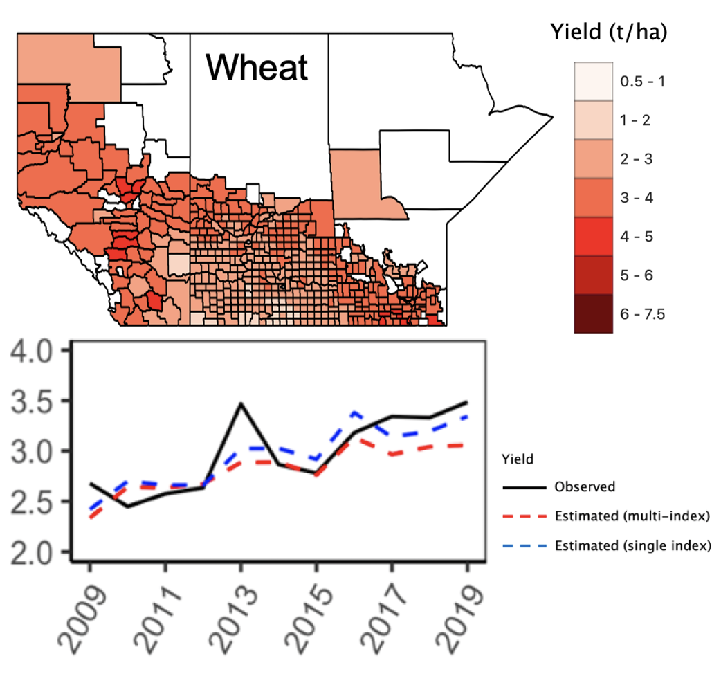
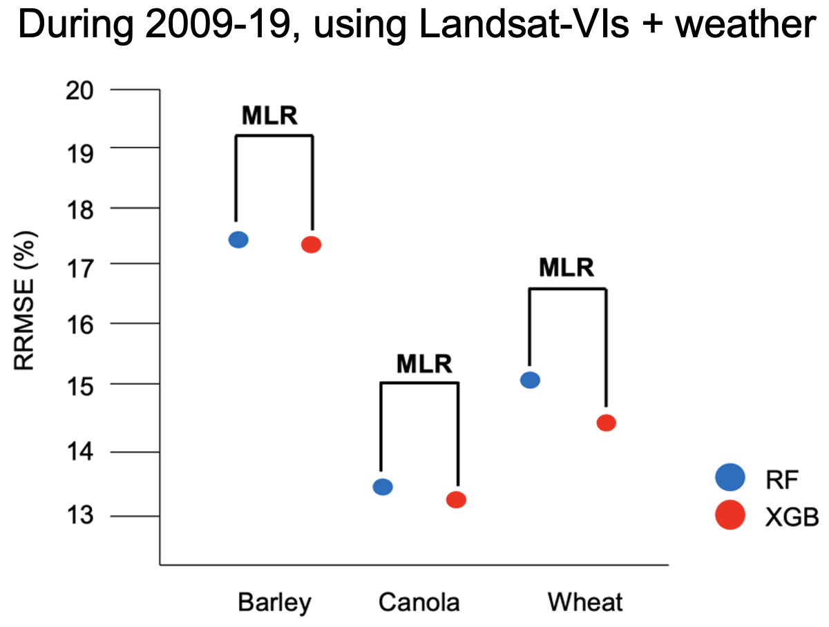
A remote sensing-based approach enables timely and consistent estimation of yields in different agricultural regions. Satellite-based yield prediction models have typically employed only vegetation indices as predictors. We investigate how the addition of weather data as predictors to a satellite vegetation index-based model and the choice of modeling algorithm influenced yield estimation accuracy. We tested machine learning models (Random Forests and Extreme Gradient Boosting), alongside multiple linear regression as baseline, using municipality level data (2009-2019) for three key crops (barley, canola, wheat) in the Canadian Prairies. Landsat 7 & 8 and Sentinel-2 were used as the main satellite sources, while MODIS-based models were built as a baseline.

The development of a field-scale crop yield prediction model using satellite and environmental data
(With Navin Ramankutty, Nathaniel K. Newlands, Nicholas C. Coops, Bhusan Gopaluni)
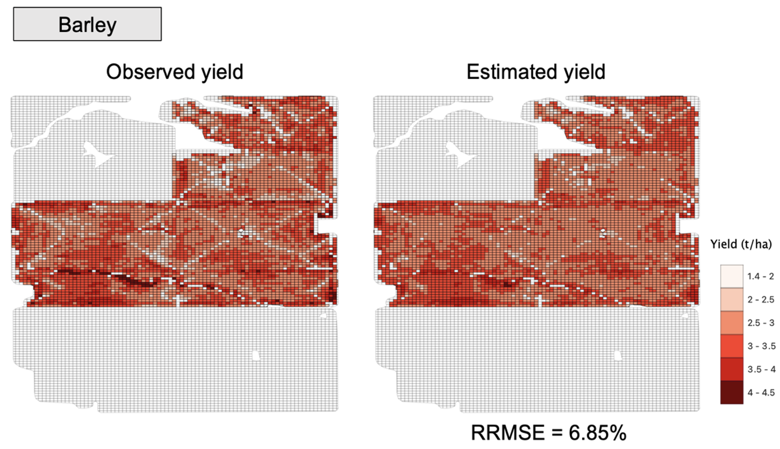
Recently, spatially detailed ground-based field-scale yield datasets focused on large commercial farms have become available providing a timely opportunity for using high spatial resolution observational data for model training. We develop a crop-yield prediction model driven using Landsat-based vegetation indices and biophysical data and calibrated using field-scale yield monitor data. We leveraged 131 field-years of yield data for three key crops from one farm in the Canadian Prairies to assess how different combination of data inputs, and choice of modeling algorithm influenced estimation accuracy. We conducted a thorough assessment using advanced machine and deep learning models and different combinations of inputs including satellite vegetation indices, weather, and other biophysical data.
Partner with me to develop diverse datasets and tools (machine/deep learning) for data-driven sustainable solutions tailored to the needs of diverse actors within an agricultural ecosystem.